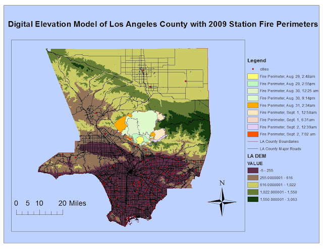
The reference map above displays the evolution of the Station Fire's perimeters as it grew and ran its course within Los Angeles County, with data retrieved from Los Angeles County Enterprise GIS. The perimeters on the map were recorded during various times between August 29, 2009 through September 2, 2009. The blaze spread rapidly, as you can see by comparing the tiny yellow starting perimeter to the huge orange perimeter just two days later.Also included in the map is a digital model of the elevation of Los Angeles County, which when combined with the knowledge of the Station Fire's perimeter, indicates that the fire happened in higher elevation among the national forest. Also on the reference map are some of the major roads and cities within L.A. county. Thus, you can see that the Station Fire became a big threat to some populated cities near the fire perimeters and also may have caused damage to major roads/highways of L.A. which could have caused more of an adverse effect on traffic and transportation.
The thematic map above intends to show the proximity of the 2009 Station Fire to schools in Los Angeles County. It also includes information/data from the California Department of Forestry and Fire Protection, which is the fire threat among all locations in California. This map focuses on the fire threat throughout Los Angeles County. I wondered how a huge fire like this could affect the school system, its schedule, and its students. I hypothesized that it would possibly close down some schools to put the kids out of danger. Also, I chose to include the fire threat component to show which schools had a higher probability of being affected by wildfires in the first place.
From the map, you can see that the Station Fire, indeed, occurred in an area where the fire threat is extremely high. It also progressed in relatively the same area of high elevation and high fire threat. Fortunately, there are virtually no schools located in that same high fire threat zone where the Station Fire occurred. Thus, fire threat must be a factor in placing and location schools, to ensure the safety of the students and the school itself. Most of the Los Angeles County schools are located and clustered at a lower elevation in the more metropolitan areas so many weren't directly threatened by the flames. However, there were some schools that were located in medium-fire threat zones that were very close in proximity to the perimeters of the Station Fire, as indicated by the clusters of green dots that border the south of the fire perimeters. According to reports by the Los Angeles Times, schools delayed their start of the new school year due to the fire, remaining closed to students so they would be out of harm's way. Those schools were ones in the La Canada Unified, Glendale Unified, and Acton-Agua Dulce Unified Districts (which are represented by those green dots along the border of the fire perimeters). Others in places like the Pasadena Unified, Los Angeles Unified, and Saugus Union altered and limited outdoor activities/sports practices and more. Of course, the schools took these measures to protect the health of its young students. As the Center for Disease Control and Prevention (CDC) has stated, children are more likely to feel the adverse effects and threats from smoke because their airways are still developing and they breathe more air per pound of body weight than adults.
In conclusion, measures were taken to protect the vulnerability of children and their health in schools that were close to the location of the Station Fire, like I predicted. Schools with the highest fire threat were the ones closest to the actual Station Fire, and closed down to put students out of harm's way. However, I did find some information that surprised me. According to a report from ABC news, some high schools in the affected area acted as evacuation centers for those that were forced out of their homes. Those schools included La Canada High School and La Crescenta High School. I'm guessing that, even though they were still part of the danger zones, they were the most efficient place to provide shelter for displaced people. Nevertheless, maps like the reference and thematic ones above act as extremely helpful aides to discover information for such important emergencies like the 2009 Station Fire in Los Angeles County. Thus, GIS proves to be extremely useful and pertinent in society. Maps created with GIS can help experts determine important attributes of the fire such as its spread, patterns within it, its causations, its effects, and more. From there, communities can take action. Maps and spatial analysis become vital in today's world in informing and protecting its inhabitants.
Bibliography
Centers for Disease Control and Prevention. "Wildfires." Centers for Disease Control and Prevention. n.p. 2012. Web. 5 Dec. 2012. http://emergency.cdc.gov/disasters/wildfires/facts.asp
"Fire Threat." California Department of Forestry and Fire Protection. n.p. 2007. Web. 2 Dec. 2012. http://frap.cdf.ca.gov/data/frapgisdata/download.asp?rec=fthrt
"Schools Remain Closed Because of Station Fire." L.A. Now. Los Angeles Times. 1 Sept. 2009. Web. 5 Dec. 2012.
"Station Fire." Inciweb. U.S. Forest Service. 10 Nov. 2009. Web. 5 Dec. 2012. http://www.inciweb.org/incident/1856/
"53 Structures Burned in Station Fire." ABC Local. ABC News. 31 Aug. 2009. Web. 5 Dec. 2012. http://abclocal.go.com/kabc/story?section=news/local/los_angeles&id=6991309 school evacuation centers
**Other sources for GIS data include Los Angeles County Enterprise GIS (for Station Fire Perimeters) and http://gis.ats.ucla.edu/Mapshare/ (both given to the class as links).

No comments:
Post a Comment